Garmin eTrex Legend — The BEST GPS With the eTrex Legend, Garmin has loaded a full basemap of North and South America into one small unit. The Legend is also designed to provide precise GPS positioning using correction data obtained from the Wide Area Augmentation System (WAAS). This product will provide position accuracy to less than three meters when receiving WAAS corrections.
Where to Buy Garmin eTrex Legend Online
| STORE |
PRICE |
SHIP TIME |
AVAILABILITY |
WAL*MART |
$135.44 |
1-7 days |
YES |
| Amazon |
$169.99 |
|
YES |
American Backyard |
$199.99 |
|
YES |
 TigerDirect TigerDirect |
|
|
NO |
|
| 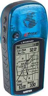
The basemap contains lakes, rivers, cities, interstates, national and state highways, railroads and coastlines. The eTrex Legend is also equipped with additional memory totaling eight megabytes. The added memory allows the eTrex Legend to accept downloaded map data from Garmin's entire line of MapSource® CD-ROMs, including Fishing Hot Spots®. The eTrex Legend comes in a brightly-colored translucent blue case that really makes the unit stand out. New to the product design, Garmin will include marine aids to navigation in addition to the basemap. These navigational aids will be pre-loaded into each unit from the factory.
Package includes:
eTrex LegendT
Database
Marine Point Database
Basemap
Americas Highway or
Atlantic Highway or
Pacific Highway
PC interface cable
Wrist strap
User's guide
Quick reference guide
|
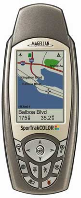
Magellan SporTrak Color SporTrak Color provides superior tracking and accuracy, showing your position to within 3 meters, even in difficult environments such as cities or mountains. Featuring an impressive 10 MB North American, built-in mapping database, SporTrak Color puts rich color maps at your fingertips. The large, high contrast, full color 240 x 160 pixel display enables you to easily find your location, heading and route. An additional 22 MB for North America of memory enables you to expand your mapping capabilities by uploading detailed maps from optional Magellan MapSend® software products. A clear advantage over the competition, SporTrak Color also offers a built-in barometer, giving you an advance on the weather and an innovative 3-axis compass for superior navigational accuracy no matter how you hold it. Built tough, SporTrak Color is waterproof and rugged enough to go with you on any adventure.
Where to Buy Magellan SporTrak Color Online
| STORE |
PRICE |
SHIP TIME |
AVAILABILITY |
| WAL*MART |
|
|
NO |
| Amazon |
$299.00 |
1-5 days |
YES |
American Backyard |
|
|
NO |
| TigerDirect |
|
|
NO |
|
 The features of the SporTrak Color give you all of the great advantages of GPS navigation in a full-color, compact, lightweight, rugged package: The features of the SporTrak Color give you all of the great advantages of GPS navigation in a full-color, compact, lightweight, rugged package:
- Full Color
See where you are and where you’re going in vivid color on a large 240 x 160 pixel, high contrast, full-color display. Color enables you to easily see your location and route, and to easily differentiate between roads, interstates, parks, waterways, airports and other Points of Interest at a glance.
- Barometer
Like carrying your own little weather station, there’s no need to worry about what might be rolling in.
- 3-Axis Compass
A clear advantage over the competition, SporTrak Color offers an innovative 3-axis compass which orients no matter how it's held, providing added confidence. You don't need to hold the unit level like a compass or a 2-axis electronic compass (found in many GPS devices), to get an accurate reading. Hold it naturally.
- Accurate
The SporTrak Color uses WAAS (Wide Area Augmentation System) and the European Geostationary Navigation Overlay System (EGNOS) to provide the maximum GPS accuracy and reliability available. Tracking up to 12 satellites to locate your position to within 3 meters, you can rest assured that with the SporTrak Color, you will know where you are.
- Easy to use
An intuitive interface and keypad provide direct access to key features, putting the power of GPS at your fingertips.
- Built-in mapping of North America and expandability
Start navigating right away with the impressive, 10 MB, built-in mapping database of North America, including highways, major roads, parks, waterways, airports, cities and marine navigation aids, such as buoys, beacons, lights and more. Easily expand your mapping capability by downloading detailed maps from optional Magellan MapSend software products.
Full Featured Navigation
Nine customizable graphic navigation screens include a map, compass and speedometer with text readouts of heading, bearing, speed, direction, ETA, and more. Choose from 12 built-in coordinate systems and 76 datums including Latitude/Longitude, Universal Transverse Mercator, and Military Grid Reference System.
|
Garmin GPSMAP 76CS The latest color-display technology gives the 76CS the brightest, sunlight-readable displays available. And with brand-new state-of-the-art receivers and powerful microprocessors, this unit will give you a quick and steady fix. In addition, the GPSMAP 76CS boasts a built-in electronic compass and barometric altimeter.
Where to Buy Garmin GPSMAP 76CS Online
| STORE |
PRICE |
SHIP TIME |
AVAILABILITY |
| WAL*MART |
$464.42 |
1-7 days |
YES |
| Amazon |
$549.99 |
1-5 days |
YES |
| American Backyard |
|
|
NO |
 TigerDirect TigerDirect |
$485.99 |
|
YES |
|
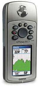
Both the Garmin 76C and Garmin 76CS have the familiar GPS 76-family keypads and styling, with 115 MB of memory, an Americas Autoroute basemap, and a Marine Point database. Fast USB connectivity makes loading charts and maps quick and easy, while navigation instructions can be shared with repeaters, plotters, and autopilots using NMEA protocols through the dedicated serial port.
They’re waterproof and fully compatible with MapSource® products like BlueChart®, U.S. Topo 24K, and City Select® (which provides detailed streets for turn-by-turn guidance).
Product Details:
Features Include:
- WAAS-enabled, 12 parallel channel GPS receiver
- Built-in quad-helix antenna with remote antenna capability
- Electronic compass displays accurate heading while standing still
- Barometric sensor with automatic pressure trend recording
- Elevation computer provides current elevation, ascent/descent rate, minimum/ maximum elevation, total ascent and descent, average and maximum ascent and descent rate
- 115-MB internal memory for loading MapSource detail, including marine cartography
- USB connectivity for quick chart and map downloads
- 6.2" H x 2.7" W x 1.4" D unit dimensions
- Sunlight-readable display with 256-color transreflective TFT display (1.5" W x 2.2" H; 2.6" diagonally); color operating system with new look-and-feel
- Weighs 7.6 ounces (with batteries)
- LED-backlit display and keypad
- Up to 20 hours battery life (uses two AA alkaline batteries)
- Permanent user-data storage; no memory battery required
- Includes a built-in Americas Autoroute basemap with auto-routing capabilities, including highways, exits, and tide data (U.S. only)
- Internal memory is pre-loaded with a Marine Point database
- Water resistant to IEC 60529 IPX7 standards (can be submerged in one meter of water for 30 minutes); rugged and waterproof housing that floats
- 1000 user waypoints with name and graphic symbol; 50 reversible routes
- Position formats include Lat/Lon, UTM, Loran TDs, Maidenhead, MGRS, user grid, and more
- Audible alarms for anchor drag, arrival, off-course, proximity waypoint, and clock
- Large-numbers option for easy viewing; dual-position display mode
- Trip computer provides odometer, stopped time, moving average, overall average, total time, max speed, and more
- 10,000 point automatic track log; 20 saved tracks let you retrace your path in both directions
- Built-in celestial tables for best time to fish, plus sun and moon calculations
Compatible with most MapSource products including BlueChart, City Select, U.S. Topo 24K, U.S. TOPO, and Recreational Lakes with Fishing Hot Spots.
|
Garmin eTrex Legend C The eTrex Legend® C is Garmin's exciting, new, pocket-sized handheld that brings color, automatic routing, longer battery life, plus more to our popular-selling eTrex Legend. You won't miss a thing when you take this colorful, lightweight, easy-to-use handheld out hiking, biking, boating or even geocaching. The eTrex Legend C along with the eTrex Vista C are Garmin's smallest, least expensive products to combine a color TFT display and advanced GPS routing capabilities in a waterproof design.
Where to Buy Garmin eTrex Legend C Online
| STORE |
PRICE |
SHIP TIME |
AVAILABILITY |
| WAL*MART |
$283.44 |
1-7 days |
YES |
| Amazon |
$349.99 |
1-5 days |
YES |
| American Backyard |
|
|
NO |
| TigerDirect |
|
|
NO |
|
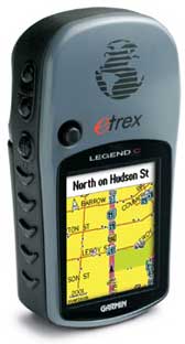
Outdoor enthusiasts will love the latest improvements made to the eTrex Legend C:
- 256-color, sunlight-readable display makes it easy to distinguish map details and see where you’re going
- Automatic route generation, off-route recalculation, turn-by-turn directions with alert tones, and icon-driven menus for finding points of interest (when combined with Garmin’s optional MapSource® CDs) navigate you safely to your destination
- Longer battery life for more hours of outdoor enjoyment
- Mini-USB port for fast, convenient download of map data from Garmin’s entire library of optional MapSource CDs using a PC
- 24 MB of internal memory for lots of map storage
Of course the eTrex Legend C still includes those popular features that users have come to love and expect in the eTrex product line, such as a compact, lightweight, waterproof design and user-friendly interface. The eTrex Legend C is WAAS-enabled, and like all eTrex units, the primary controls are oriented on the side of the unit, so the user can conveniently operate it with one hand. Also, an innovative rocker switch is located on the face of the unit that enables the user to input data easily, scroll through menus, or pan the map page.
|
Lowrance iFinder Plus Personal, precise, powerful, pocket-size, iFINDER® mapping GPS/WAAS navigation with digital recording, expandable memory, and unique FaceOffs®. The only way to go with ease and style! Comes with Black FaceOffs® cover.
Also available with the Plus package - The iFINDER® Plus has the same great features of the standard model, with the added plus of exclusive MapCreateT mapping software, one MMC/SD memory card, and an MMC/SD card reader with USB connector - for making custom, high-detail mapping.
Where to Buy Lowrance iFinder Plus Online
| STORE |
PRICE |
SHIP TIME |
AVAILABILITY |
| WAL*MART |
|
|
NO |
| Amazon |
$174.99 |
1-5 days |
YES |
| American Backyard |
$380.92 |
|
OUT of STOCK |
| TigerDirect |
|
|
NO |
|
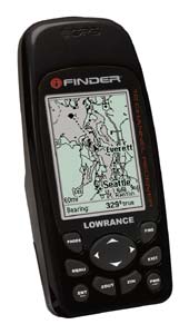
Display
 160V x 120H resolution - 19,200 total pixels 160V x 120H resolution - 19,200 total pixels
 1.7" x 2.2" display size 1.7" x 2.2" display size
 High contrast Film SuperTwist High contrast Film SuperTwist
 Backlit screen Backlit screen
 4-level grayscale 4-level grayscale
 Excellent viewing in direct sunlight Excellent viewing in direct sunlight
 Optional FaceOffs® covers in red, blue, yellow, black, and camouflage also available Optional FaceOffs® covers in red, blue, yellow, black, and camouflage also available
Specs
 Weighs 7.62oz/216g with 2 AA batteries loaded (batteries not included) Weighs 7.62oz/216g with 2 AA batteries loaded (batteries not included)
 5.588x2.549x0.955 inches / 14.2x6.5x2.4 cm pocket-sized 5.588x2.549x0.955 inches / 14.2x6.5x2.4 cm pocket-sized
GPS/Mapping
 Precision 12- parallel channel GPS+ WAAS receiver Precision 12- parallel channel GPS+ WAAS receiver
 Antenna port for connecting optional external GPS+WAAS FA-8 antenna Antenna port for connecting optional external GPS+WAAS FA-8 antenna
 Dual Easy/Advanced operation modes Dual Easy/Advanced operation modes
 Built-in, detailed Lowrance background map Built-in, detailed Lowrance background map
 Internal back-up memory Internal back-up memory
 One MMC/SD digital media memory card slot for mapping and recording capabilities One MMC/SD digital media memory card slot for mapping and recording capabilities
 Optional Mapping Accessories Pack that includes MapCreate™ mapping software, one 16MB digital MMC memory card, and an MMC/SD card reader with USB connector Optional Mapping Accessories Pack that includes MapCreate™ mapping software, one 16MB digital MMC memory card, and an MMC/SD card reader with USB connector
 1,000 waypoints/1,000 event markers 1,000 waypoints/1,000 event markers
 Up to 100 savable and retraceable plot trails, with up to 10,000 points in any trail Up to 100 savable and retraceable plot trails, with up to 10,000 points in any trail
 40 map zoom ranges, 0.02–4,000 miles 40 map zoom ranges, 0.02–4,000 miles
 Easy point-and-map cursor navigation/ route planning Easy point-and-map cursor navigation/ route planning
 Compatible with optional Lowrance FreedomMaps™ electronic maps Compatible with optional Lowrance FreedomMaps™ electronic maps
|
Garmin eTrex Truly a small wonder, the eTrex takes the best features of a 12 parallel channel
GPS receiver and put them into a six ounce package that is only four inches high
and two inches wide. The result is a unit that will literally fit in the palm of
your hand.
Where to Buy Garmin eTrex Online
| STORE |
PRICE |
SHIP TIME |
AVAILABILITY |
| WAL*MART |
$81.32 |
1-7 days |
YES |
| Amazon |
$93.99 |
1-5 days |
YES |
American Backyard |
$102.53 |
|
YES |
| TigerDirect |
|
|
NO |
|
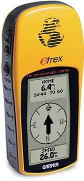 Besides its small size, mariners and outdoorsmen will likely notice the sleek design of the eTrex. All buttons are located on either side of the unit, allowing for simple, one-handed operation that won't obstruct your view of the display. In fact, the eTrex features only five operator buttons for the ultimate in user-friendly design. Thanks to its bright yellow case, the eTrex will be hard to misplace and easy to find in any boat or backpack. The eTrex is completely waterproof so it can take an accidental splash or dunk in the water and still continue to perform. Besides its small size, mariners and outdoorsmen will likely notice the sleek design of the eTrex. All buttons are located on either side of the unit, allowing for simple, one-handed operation that won't obstruct your view of the display. In fact, the eTrex features only five operator buttons for the ultimate in user-friendly design. Thanks to its bright yellow case, the eTrex will be hard to misplace and easy to find in any boat or backpack. The eTrex is completely waterproof so it can take an accidental splash or dunk in the water and still continue to perform.
Inside the eTrex, you will find the proven performance of a 12 parallel channel GPS receiver that will run for 22 hours on just two AA batteries. The eTrex will store up to 500 user waypoints with graphic icons and boasts Garmin's exclusive TracBack® feature that will reverse your track log and help you navigate your way back home. In addition, the eTrex uses animated graphics that will help you identify your marked waypoints quickly and easily.
Package includes:
eTrex®
Wrist strap
User's guide
Quick reference guide
|
Garmin GPSMAP 60CS The GPSMAP® 60CS and GPSMAP 60C are new all-purpose units-packed with exciting new features and delivering the kind of color that consumers want in their handheld GPS's. These lightweight, rugged, waterproof units raise the bar to offer a 256-color, highly reflective display that provides easy viewing in almost any lighting condition. This transreflective TFT provides excellent viewing while maximizing your battery life (20 hours, typical use).
Where to Buy Garmin GPSMAP 60CS Online
| STORE |
PRICE |
SHIP TIME |
AVAILABILITY |
| WAL*MART |
|
1-7 days |
NO |
| Amazon |
$399.94 |
1-5 days |
YES |
| American Backyard |
|
|
NO |
 TigerDirect TigerDirect |
$424.99 |
|
YES |
|
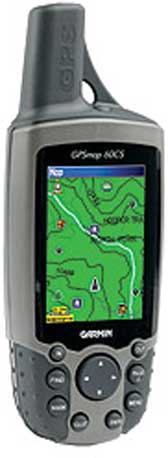 Both the GPSMAP 60CS and GPSMAP 60C are packed with extra features, including rapid automatic route calculation, an integrated outdoor calendar, a dedicated geocaching mode, and indoor/outdoor GPS games that turn the outdoors into a giant gameboard. Both the GPSMAP 60CS and GPSMAP 60C are packed with extra features, including rapid automatic route calculation, an integrated outdoor calendar, a dedicated geocaching mode, and indoor/outdoor GPS games that turn the outdoors into a giant gameboard.
The GPSMAP 60CS also offers an electronic compass and barometric altimeter for highland adventures. These sensors, when combined with GPS technology, provide enhanced bearing and elevation readings.
- Electronic compass displays accurate heading while standing still
- Barometric sensor with automatic pressure trend recording
- Sunlight-readable display with 256-color transreflective TFT display (1.5" W x 2.2" H; 2.6" diagonally); color operating system with new look-and-feel
- Faster processor, with auto routing, turn-by-turn directions, and audio alerts along city streets or trails when using MapSource® City Select® or 24K Topo software (optional software)
- 56 MB of internal memory for storing map detail
- Permanent user data storage
- Each day’s best hunting and fishing times—along with sunrise/sunset times—on the integrated Outdoor Calendar
- Special geocaching navigation mode
- Geolocation games, such as Virtual Maze, Nibbons, Geko™ Smak, Memory Race, and Gekoids
- Fast map transfer, with support for both USB and serial port interfaces
- Detailed basemap with general map data, including highways, major roads, river, lakes, and borders
- Dedicated "mark", "page", "enter", "quit", "menu", "find", and "zoom out/in" buttons; four-position rocker pad
- 2.4" x 6.1" x 1.3" (W x H x D) unit dimensions
- Weighs 5.4 ounces (without batteries), 7.5 ounces (with batteries)
- WAAS GPS receiver with accuracy to 10 feet in North America; built-in quad-helix antenna for better satellite reception
- 20 hours of battery life under typical-use conditions (uses two "AA" batteries)
- Multi-platform navigation for easy navigation in a car, in a boat, or on foot
- Accepts data from MapSource products (City Select for driving, U.S. Topo and 24K Topo for hiking, Recreation Lakes for freshwater, and BlueChart® for saltwater applications)
- Waterproof to IEC 60529 IPX7 standards (can be submerged in one meter of water for up to 30 minutes)
- 50 reversible routes, 10,000 track points with TracBack® technology (navigate to any track point on the displayed map), and 1000 waypoints with additional graphical icons for location identification
- Proximity alerts for anchor drag, arrival, off-course, proximity waypoint; built-in alarm clock
- User-configurable track-line color, waypoint projection, display color scheme, large-numbers option, audio tones, and pages (turn on/off main pages or change the sequence in which they appear)
- Elevation computer provides current elevation, ascent/descent rate, minimum and maximum elevation, total ascent and descent, average and maximum ascent and descent rate
- Trip computer provides odometer, stopped time, moving average, overall average, total time, max speed, and more
|
Garmin eTrex Vista The eTrex Vista combines a basemap of North and South America, with a barometric altimeter and electronic compass. The compass provides bearing information while you're standing still and the altimeter determines your precise altitude. The Vista is also designed to provide precise GPS positioning using correction data obtained from the Wide Area Augmentation System (WAAS). This product will provide position accuracy to less than three meters when receiving WAAS corrections.
Where to Buy Garmin eTrex Vista Online
| STORE |
PRICE |
SHIP TIME |
AVAILABILITY |
| WAL*MART |
$218.88 |
1-7 days |
YES |
| Amazon |
$218.94 |
1-5 days |
YES |
American Backyard |
$282.72 |
|
YES |
| TigerDirect |
|
|
NO |
|
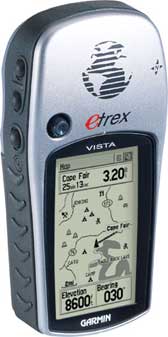 The eTrex Vista also boasts an internal memory capacity of 24 megabytes, which allows it to accept downloaded mapping data from Garmin's MapSource® CD-ROMs, including Fishing Hot Spots®. A silver case gives this unit a high-tech look. New to the product design, Garmin will include marine aids to navigation in addition to the basemap. These navigational aids will be pre-loaded into each unit from the factory. The eTrex Vista also boasts an internal memory capacity of 24 megabytes, which allows it to accept downloaded mapping data from Garmin's MapSource® CD-ROMs, including Fishing Hot Spots®. A silver case gives this unit a high-tech look. New to the product design, Garmin will include marine aids to navigation in addition to the basemap. These navigational aids will be pre-loaded into each unit from the factory.
Package includes:
eTrex Vista® Database
Marine Point Database
Basemap
Americas Highway or
Atlantic Highway or
Pacific Highway
PC interface cable
Wrist strap
User's guide
Quick reference guide |